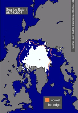
Die Ausdehnung des arktischen See-Eises liegt aktuell 2 Millionen Quadratmeilen unter dem langjährigen Durchschnitt, wie jüngste Forschungsergebnisse auf Grundlage von Satellitenaufnahmen ergeben:
Arctic sea ice has shrunk to the second-lowest level since record-keeping began three decades ago, a group of international researchers determined yesterday, a revelation underscoring how rapidly climate change is transforming ecosystems in northern latitudes.
The extent of Arctic sea ice is now 2 million square miles below the long-term average for Aug. 26, according to the International Arctic Research Center and the Japanese Aerospace Exploration Agency, a figure that is within 400,000 square miles of the all-time record low set in September 2007.
This figure is already below the long-term average for September ice cover and because the ice traditionally reaches its minimum level in mid-September, researchers warned that a new low might be recorded within weeks.
The National Snow and Ice Data Center (NSIDC), which independently analyzes Arctic ice cover, will announce today that it has reached the same conclusion, based on a five-day mean of satellite measurements.
Die Bestätigung des NSIDC kam heute:
Update 9:15 am MT August 27:
Arctic sea ice extent on August 26 was 5.26 million square kilometers (2.03 million square miles), a decline of 2.06 million square kilometers (795,000 square miles) since the beginning of the month. Extent is now within 430,000 square kilometers (166,000 square miles) of last year’s value on the same date and is 1.97 million square kilometers (760,000 square miles) below the 1979 to 2000 average.
— Schlesinger
(Grafik: Credit: National Snow and Ice Data Center)

